
Published August 21, 2026
Exploring Mount Lemmon: A Local's Guide to Tucson's Mountain Escape

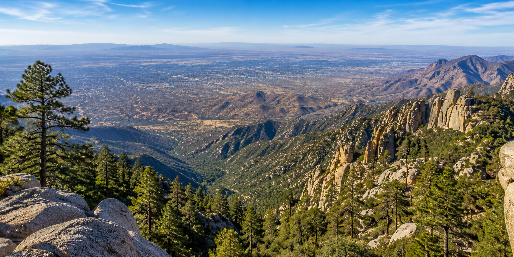
One of my favorite things about living in Tucson is how quickly the landscape can change.
You can start your morning surrounded by saguaros and Sonoran Desert vegetation, drive north toward the Santa Catalina Mountains, and before long find yourself among oak and pine forests at elevations thousands of feet above the Tucson valley.
That's Mount Lemmon.
For people who are new to Tucson, the mountain can almost feel like it belongs somewhere else. But for those of us who live here, Mount Lemmon is part of the rhythm of Southern Arizona—a place for scenic drives, hiking, picnics, cycling, camping, winter snow, or simply getting a completely different perspective on the desert below.
And getting there is part of the experience.
The Catalina Highway climbs from the desert into the Santa Catalina Mountains through a remarkable series of landscapes, eventually reaching the forests, trails, recreation areas, and small community of Summerhaven near the upper elevations.
Let's look at what makes Mount Lemmon so unusual, what you'll find along the way, and a few practical things worth knowing before you head uphill.
What Makes Mount Lemmon So Different From Tucson Below?
Mount Lemmon rises from the Sonoran Desert to an elevation above 9,000 feet in the Santa Catalina Mountains, creating dramatic changes in temperature, vegetation, and scenery over a relatively short distance. The mountain is part of a regional “Sky Island” landscape where higher elevations support environments very different from the desert surrounding them.
Mount Lemmon makes much more sense once you understand the idea of a Sky Island.
The mountain isn't literally an island, of course. The term describes isolated mountain ranges whose higher-elevation ecosystems are surrounded by dramatically different lower-elevation environments.
The Arizona Geological Survey describes the Santa Catalina Mountains as rising from the Sonoran Desert to more than 9,000 feet at Mount Lemmon's summit, with changing geology, climate, and vegetation producing a complex series of mountain landscapes.
That change is visible almost immediately when you begin driving uphill.
Lower elevations are unmistakably Sonoran Desert.
Continue climbing and the vegetation gradually changes. Desert plants give way to grassier and woodland environments, followed by increasingly forested landscapes at higher elevations.
That's one reason the drive feels like much more than transportation from Tucson to the top.
You're watching Southern Arizona change around you.
The Catalina Highway Is Part of the Experience
The Catalina Highway—also called the Sky Island Scenic Byway—is a paved mountain road that climbs nearly 6,000 feet over approximately 24 miles from the Sonoran Desert toward Mount Lemmon's forested upper elevations. Scenic pullouts, geological formations, and changing vegetation make the drive itself one of the mountain's major attractions.
If you've never driven the Catalina Highway before, I recommend thinking of the road as part of your Mount Lemmon visit rather than something you simply need to get through.
According to the U.S. Forest Service's Mount Lemmon and Catalina Highway recreation guide, the paved scenic route climbs nearly 6,000 feet in about 24 miles.
Along the way you'll encounter overlooks, rock formations, picnic areas, trail access points, and increasingly expansive views over Tucson.
The Forest Service compares the ecological transition to experiencing a much longer northward journey because so many different environments appear during one relatively short mountain drive.
There is also a practical side to the road.
It's winding.
There are blind turns.
Cyclists regularly use it.
Wildlife may cross it.
The Forest Service specifically recommends using designated pullouts for sightseeing and allowing faster traffic to pass rather than stopping along the roadway.
This is definitely a drive where slowing down—in the appropriate places—is part of the point.
What Can You Do on Mount Lemmon?
Mount Lemmon offers year-round outdoor recreation, although specific activities depend on season, weather, closures, and current forest conditions. Visitors can explore hiking trails, picnic areas, campgrounds, scenic overlooks, cycling routes, forested recreation areas, and seasonal winter activities while also visiting Summerhaven and other destinations near the upper mountain.
There isn't really one Mount Lemmon experience.
That's one of the things I enjoy about it.
Some people head up specifically to hike.
Others pack lunch and find a picnic area.
Cyclists take on the Catalina Highway as a serious climbing route.
Families may spend an afternoon exploring the upper mountain.
And sometimes the best plan is simply driving slowly, stopping at overlooks, and watching the landscape change.
Depending on current conditions and seasonal availability, activities can include:
- Hiking
- Scenic driving
- Picnicking
- Camping
- Cycling
- Wildlife observation
- Photography
- Exploring forest recreation areas
- Visiting Summerhaven
- Seasonal winter recreation
The Coronado National Forest manages much of the recreation infrastructure on Mount Lemmon, so Forest Service information is the best place to verify trails, campgrounds, day-use areas, fees, closures, and fire restrictions before a visit.
That's especially important because mountain conditions can change quickly.
Exploring Summerhaven
Summerhaven is a small mountain community near the upper elevations of Mount Lemmon. It provides a very different setting from Tucson below, with forest surroundings, residences, local businesses, and access to nearby recreation. Visitors should remember that Summerhaven is also a residential community rather than simply a recreational attraction.
Summerhaven is usually what people mean when they talk about going to “the top” of Mount Lemmon, even though the actual summit and surrounding recreation areas extend beyond the community itself.
It's small, walkable in portions, and surrounded by mountain scenery.
You'll find places to eat, small businesses, cabins and residences, and access to nearby outdoor recreation.
But there's something I think is worth remembering when visiting:
People live there.
Summerhaven isn't a theme park or purpose-built tourist village. It's a real mountain community.
That means being thoughtful about parking, private property, traffic, trash, and noise—particularly during busy weekends, holidays, fall color, or winter snow events.
A little consideration goes a long way toward making the mountain enjoyable for both residents and visitors.
Mount Lemmon Changes With the Seasons
Mount Lemmon can be visited throughout the year, but each season brings different conditions. Summer offers relief from valley temperatures but can include monsoon thunderstorms; fall brings cooler weather; winter may bring snow and road restrictions; and spring conditions can vary considerably with elevation, snowpack, wind, and changing weather.
Mount Lemmon doesn't really have one season.
It can sometimes feel like several seasons are happening on the mountain at once.
Summer
Summer is one of the most popular times to head uphill because higher elevations are generally cooler than the Tucson valley.
But “cooler” doesn't mean conditions are always mild.
The Forest Service cautions visitors about summer heat at lower elevations as well as monsoon storms and flash flooding. Mountain thunderstorms can develop rapidly, so hikers and other outdoor visitors should pay attention to current forecasts.
Fall
Fall can bring crisp temperatures and seasonal changes in higher-elevation vegetation.
Conditions may be especially pleasant for hiking and scenic driving, but temperatures can change substantially between Tucson and the upper mountain.
Winter
Mount Lemmon can receive snow even while Tucson remains dry and relatively mild below.
Snow and ice can affect road access, parking, trails, and recreation areas.
Winter conditions are one of the most important reasons to check road status before leaving home rather than assuming the highway will be fully accessible.
Spring
Spring can be beautiful, but conditions vary by elevation.
Lower portions of the mountain may feel warm while higher elevations remain cool, windy, or affected by lingering winter conditions.
Layers are useful almost any time of year.
Why Is Mount Lemmon So Much Cooler Than Tucson?
Higher elevations are generally cooler because air temperature typically decreases as elevation increases, although the exact difference varies with weather, season, time of day, and atmospheric conditions. Mount Lemmon's large elevation gain means temperatures near the upper mountain can be substantially different from conditions in the Tucson valley on the same day.
You'll sometimes hear locals say Mount Lemmon is a specific number of degrees cooler than Tucson.
I prefer not to think of it that way.
The difference isn't fixed.
A better illustration comes from actual weather observations.
For example, National Weather Service forecasts during summer 2026 showed upper Mount Lemmon locations near 8,800 feet experiencing daytime temperatures dramatically lower than forecasts for the Tucson valley at roughly 3,000 feet during the same period. National Weather Service Tucson — Mount Lemmon forecast
The exact difference changes constantly.
Elevation, clouds, storms, wind, humidity, and season all matter.
So rather than assuming “Mount Lemmon is always X degrees cooler,” check the actual forecast for Mount Lemmon or Summerhaven before you leave.
The National Weather Service Tucson office provides mountain-specific forecasts, which are much more useful than relying on Tucson's valley forecast.
Hiking on Mount Lemmon
Mount Lemmon provides access to a large network of trails ranging from relatively short forest walks to demanding mountain routes. Elevation, distance, exposure, trail condition, weather, and seasonal closures can significantly change the difficulty of an outing, so hikers should select routes based on current conditions and their own preparation and ability.
One of the great things about hiking Mount Lemmon is the variety.
Trails pass through environments that look completely different from one another depending on elevation.
But mountain hiking deserves a little more planning than simply choosing an appealing trail name.
Before heading out, consider:
- Trail distance
- Elevation gain
- Starting elevation
- Current weather
- Water availability
- Trail condition
- Recent wildfire impacts
- Seasonal closures
- Monsoon activity
- Snow or ice during colder months
The Forest Service also advises visitors not to assume reliable drinking water will be available everywhere on the mountain.
Bring what you need rather than depending on finding water at your destination.
And during monsoon season, weather deserves particular attention. A sunny morning in Tucson doesn't guarantee a storm-free afternoon at higher elevations.
What Locals Check Before Driving Up Mount Lemmon
Direct Answer: Before heading up Mount Lemmon, it's useful to check the mountain-specific weather forecast, road status, Coronado National Forest alerts, fire restrictions, and any closures affecting trails or recreation areas. Conditions at higher elevations can differ substantially from Tucson, and temporary restrictions can occur because of snow, wildfire danger, storms, construction, or other hazards.
This is probably the most practical habit I can share:
Check before you drive.
Not yesterday.
Not based on what the weather looks like from your backyard.
Check that day.
The Forest Service notes that Mount Lemmon is generally a year-round destination, but the highway can close because of snow or fire danger. U.S. Forest Service Mount Lemmon Recreation Guide
Before leaving Tucson, check:
| What to Check | Why It Matters |
|---|---|
| Mountain weather | Conditions may be very different from Tucson |
| Road status | Snow, ice, fire, or other events can affect access |
| Forest Service alerts | Trails or recreation sites may be temporarily closed |
| Fire restrictions | Rules can change with wildfire conditions |
| Day-use requirements | Some developed recreation sites may require fees |
| Water availability | Don't assume potable water will be available |
| Clothing and layers | Temperatures can change substantially with elevation |
| Fuel and supplies | Plan ahead rather than assuming everything will be available uphill |
For current road information, the Forest Service directs visitors to the Pima County Sheriff's Department road-condition line at 520-351-3351. Because contact information and procedures can change, it's also smart to confirm current instructions through official Forest Service or Pima County resources before traveling.
Understanding Day-Use Fees and Recreation Areas
Some developed recreation sites on Mount Lemmon require day-use or other recreation fees, while other areas may not. Different passes and concessionaire-managed facilities can have different rules, so visitors should verify requirements for the specific trailhead, picnic area, campground, or recreation site they plan to use.
This is another place where it's better not to make assumptions.
The Forest Service identifies day-use fee areas on Mount Lemmon and notes that passes may be purchased through Recreation.gov or at certain locations.
However, not every site operates exactly the same way.
Some facilities may be managed differently, and the Forest Service specifically notes that certain passes aren't valid at concessionaire-managed sites.
Rather than trying to memorize which pass applies where, check the specific recreation area's current information before your visit.
That also helps avoid relying on an old blog post—or even an old memory—when fees or operating arrangements have changed.
Why Conditions Can Change So Quickly
Mount Lemmon's elevation, mountain terrain, seasonal storms, snow, wildfire conditions, and changing ecosystems mean conditions can vary significantly over short distances and periods of time. Visitors may encounter sunshine, wind, rain, colder temperatures, or winter conditions during the same trip, making current forecasts and flexible planning particularly important.
Mountains create their own challenges.
During Tucson's summer monsoon, storms can develop around higher terrain even when much of the valley remains dry.
During winter, conditions near Summerhaven may include snow or ice while Tucson below experiences an ordinary sunny day.
And wildfire conditions can affect access or recreation even when the weather otherwise looks beautiful.
That's why Mount Lemmon rewards flexibility.
If a trail is closed, choose another appropriate activity.
If storms are developing, don't force a hiking plan.
If winter road conditions are poor, come back another day.
The mountain will still be there.
Responsible Recreation Matters
Mount Lemmon is part of the Coronado National Forest and contains sensitive mountain ecosystems, wildlife habitat, recreation areas, and residential communities. Visitors can help protect the area by staying on appropriate routes, following fire restrictions, packing out trash, respecting wildlife and private property, and following current Forest Service regulations.
Mount Lemmon receives a lot of visitors—and that means small decisions add up.
A few simple habits make a difference:
- Pack out what you bring in.
- Use established trails where required.
- Don't create unauthorized fire rings.
- Follow current fire restrictions.
- Give wildlife space.
- Don't feed animals.
- Respect private property in Summerhaven and cabin areas.
- Park only where permitted.
- Don't block roadways or emergency access.
- Leave plants, rocks, and natural features where you found them.
Responsible recreation isn't complicated.
It's simply recognizing that we're visitors in an environment shared by wildlife, residents, and everyone who comes after us.
Mount Lemmon at a Glance
Mount Lemmon combines scenic driving, forest recreation, hiking, camping, cycling, seasonal winter activities, and a dramatic elevation change within the Santa Catalina Mountains north of Tucson. Because conditions vary by season and elevation, official Forest Service, weather, and road information should be checked before each visit rather than relying on general assumptions.
| Mount Lemmon Feature | What to Know |
|---|---|
| Mountain Range | Santa Catalina Mountains |
| Summit Elevation | More than 9,000 feet |
| Scenic Route | Catalina Highway / Sky Island Scenic Byway |
| Scenic Byway Length | Approximately 24 paved miles |
| Elevation Gain on Drive | Nearly 6,000 feet |
| Upper-Mountain Community | Summerhaven |
| Recreation | Hiking, camping, picnicking, cycling, scenic driving, seasonal winter activities |
| Primary Land Manager | U.S. Forest Service, Coronado National Forest |
| Weather Source | National Weather Service Tucson |
| Road Conditions | Verify before traveling, particularly during winter or fire events |
| Best Season | Depends on the activity and current conditions |
One of Mount Lemmon's strengths is that there really isn't a single “best” season.
The experience changes throughout the year.
Frequently Asked Questions About Mount Lemmon
How far is Mount Lemmon from Tucson?
The Catalina Highway scenic route itself extends approximately 24 miles uphill, and the Forest Service describes Summerhaven and the summit area as less than an hour from downtown Tucson under typical conditions. Actual travel time varies based on starting point, traffic, weather, road conditions, and sightseeing stops.
How high is Mount Lemmon?
Mount Lemmon rises above 9,000 feet in elevation. The surrounding Santa Catalina Mountains climb dramatically from the Sonoran Desert below.
Is Mount Lemmon always cooler than Tucson?
Higher elevations are generally cooler, but there isn't a fixed temperature difference. Weather, season, storms, wind, and time of day all influence conditions. Check the mountain-specific National Weather Service forecast before traveling.
Can you visit Mount Lemmon year-round?
Generally, yes, but access and activities depend on current conditions. Snow, ice, wildfire danger, storms, road work, or other events can cause temporary restrictions or closures.
Does it snow on Mount Lemmon?
Yes. Higher elevations of Mount Lemmon can receive winter snow even when Tucson remains dry below. Snow and ice may affect highway access and recreation areas.
What is Summerhaven?
Summerhaven is a small residential and commercial mountain community near the upper elevations of Mount Lemmon. Visitors can find local businesses and access nearby recreation, but should remember that it is also home to year-round and seasonal residents.
Are there hiking trails on Mount Lemmon?
Yes. The Santa Catalina Mountains contain an extensive trail network covering different elevations, environments, distances, and difficulty levels. Check current Forest Service trail information before selecting a route.
Do I need a pass to visit Mount Lemmon?
Driving the highway itself is different from using developed recreation sites. Some Forest Service day-use areas and facilities require recreation fees, and rules vary by site. Verify the specific location you plan to use through the Forest Service or Recreation.gov.
Where should I check Mount Lemmon conditions before leaving?
For current information, use the Coronado National Forest, National Weather Service Tucson, and applicable Pima County road resources. These are more reliable for changing conditions than older travel articles or social media posts.
Final Thoughts
Mount Lemmon is one of those places that helps explain why living in Southern Arizona can be so surprising.
Tucson is unquestionably a desert city, but just beyond the valley floor is an entirely different mountain environment.
That's what makes the drive so memorable.
You're not simply heading somewhere cooler. You're traveling through changing elevations, vegetation, geology, and ecosystems until the Sonoran Desert below looks remarkably far away.
And you don't need an elaborate itinerary to appreciate it.
Sometimes Mount Lemmon means a long hike.
Sometimes it's lunch beneath the trees.
Sometimes it's watching a storm move across the valley from a scenic overlook.
And sometimes it's simply driving uphill for a few hours to remember just how much variety exists in our corner of Arizona.
For me, that's the real appeal of Mount Lemmon.
It's not one attraction or one activity.
It's another side of Southern Arizona—and one that's close enough to Tucson that you can experience the desert and the mountains in the same day.
Visitor Information Note
Road access, weather, fire restrictions, recreation-site availability, fees, trail conditions, and seasonal services can change. Before traveling, verify current conditions through the U.S. Forest Service, National Weather Service, Pima County, and other appropriate official agencies.

Tom Krieger
| The TJK Team - Realty Executives Arizona Territory
or another way