
Published September 3, 2026
Why Tucson Looks Different From Phoenix: Geography, Growth, and Development

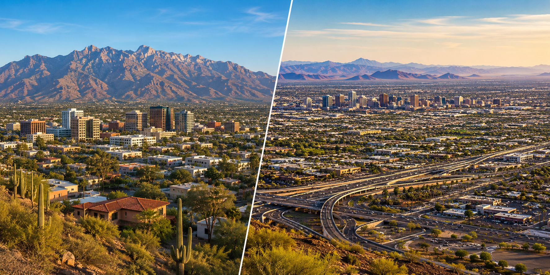
If you've spent time in both Tucson and Phoenix, you've probably noticed that they don't just feel like two different-sized versions of the same Arizona city.
They actually look different.
Phoenix stretches across an enormous metropolitan landscape, with freeways, major arterial roads, employment centers, and multiple cities blending into one another across the Salt River Valley.
Tucson feels more physically contained. Mountains remain prominent in multiple directions, the freeway network is much smaller, and undeveloped desert and mountain landscapes can appear surprisingly close to established parts of the city.
Both are in Arizona.
Both are part of the Sonoran Desert region.
Both have grown substantially over time.
So why did they develop so differently?
The answer isn't one planning decision or one historical event. It's a combination of geography, population growth, transportation infrastructure, land availability, jurisdictional boundaries, and decades of development occurring at very different scales.
Understanding those differences helps explain why driving around Tucson doesn't feel quite like driving around Phoenix—even though the two cities are only about 100 miles apart.
Why Do Tucson and Phoenix Look So Different?
Tucson and Phoenix developed within different physical landscapes and at very different metropolitan scales. Tucson occupies a mountain-framed basin where nearby ranges remain a dominant visual feature, while Phoenix expanded across the broader Salt River Valley. Population growth, transportation investment, municipal boundaries, infrastructure, and development timing further shaped the different urban forms visible today.
The easiest place to start is with a map.
Tucson sits within a basin surrounded by mountain ranges.
The U.S. Geological Survey describes the Tucson basin as a roughly 1,000-square-mile area bounded by the Santa Rita, Empire, Rincon, Tanque Verde, Santa Catalina, Tortolita, Sierrita, Black, and Tucson Mountains.
You don't need to know every range by name to notice what that means when you're standing in Tucson.
The mountains are close.
The Santa Catalinas dominate the northern skyline. The Rincons rise to the east. The Tucson Mountains sit immediately west of the city. Other ranges frame the larger basin.
Phoenix also has mountains—plenty of them.
But metropolitan Phoenix occupies a much larger urbanized landscape across the Salt River Valley, with development extending through numerous incorporated cities and communities.
So although both places share the Basin and Range geography of southern and central Arizona, people experience that geography differently at street level.
In Tucson, the surrounding mountains often feel like the edges of the city.
In Phoenix, mountain ranges and preserves frequently appear within or between portions of a much larger metropolitan area.
How Much Bigger Is Phoenix Than Tucson?
Phoenix is substantially larger than Tucson in both population and incorporated land area. Census Bureau estimates put Phoenix at about 1.67 million residents in 2025 compared with about 548,000 in Tucson. Phoenix also covered approximately 518 square miles in the 2020 Census, while Tucson covered about 241 square miles.
This difference in scale explains a lot of what you see.
According to the U.S. Census Bureau, the July 1, 2025 population estimates were approximately:
- Phoenix: 1,665,481
- Tucson: 548,371
And that's comparing the incorporated cities—not the entire metropolitan regions surrounding them.
The physical city limits are different in scale, too.
The Census Bureau reports Phoenix at approximately 518 square miles of land in 2020, compared with approximately 241 square miles for Tucson.
That doesn't mean every square mile is developed the same way.
It simply helps explain why Phoenix can seem almost endless when you're driving across it.
And once we zoom out beyond the City of Phoenix itself, the difference becomes even more noticeable.
The Phoenix metropolitan area includes large neighboring cities such as Mesa, Chandler, Scottsdale, Glendale, Tempe, Gilbert, Peoria, and others.
Tucson has surrounding municipalities and unincorporated communities too, but not at the same metropolitan scale.
How Does Geography Shape Tucson's Development?
Tucson's physical form is strongly influenced by its basin-and-mountain geography. The metropolitan area occupies relatively low terrain surrounded by prominent mountain ranges, while washes and the Santa Cruz River system cross the valley floor. Mountains, public lands, protected landscapes, drainage systems, and jurisdictional boundaries all influence where continuous urban development can occur.
Tucson's geography isn't something happening far outside the city.
It's woven directly into the urban landscape.
The U.S. Geological Survey identifies the Tucson basin as a structural depression within the Basin and Range physiographic province.
In everyday language, Tucson occupies a broad valley-like basin with mountain ranges rising around it.
That geography creates some very recognizable development patterns.
Head north and the Santa Catalina Mountains become an increasingly dominant part of the landscape.
Go west and the Tucson Mountains create a major physical break between central Tucson and development farther west.
To the east, the Rincon Mountains and associated public lands create another substantial landscape feature.
The basin floor itself is also crossed by the Santa Cruz River and numerous washes and drainage corridors.
None of this means Tucson couldn't grow.
Clearly, it did.
But growth has taken place around and between major physical features, rather than across an unlimited blank surface.
That's one reason undeveloped land can remain visually prominent even relatively close to established neighborhoods.
Is Phoenix Geography Really That Different?
Phoenix also occupies a Basin and Range landscape, but much of its metropolitan development spreads across the broad Salt River Valley. Individual mountain ranges and peaks interrupt that valley, yet large areas between them provide extensive relatively level terrain. This helped accommodate urban expansion across many adjacent municipalities as metropolitan Phoenix grew.
It's easy to oversimplify this comparison and say:
Tucson has mountains. Phoenix is flat.
That's not accurate.
Phoenix has highly visible mountains, including ranges and isolated peaks embedded throughout the metropolitan area.
The difference is more about scale and spacing.
Arizona Geological Survey research describes the Phoenix basin as underlying the western portion of the Salt River Valley. Arizona Geological Survey
Across the larger metropolitan region, extensive areas of valley floor separate many of the mountain features.
That provided room for multiple cities to expand outward and eventually grow toward one another.
Today, you can drive from Phoenix into Tempe, Mesa, Chandler, Scottsdale, Glendale, Peoria, or other municipalities without necessarily encountering an obvious break in the developed landscape.
Municipal boundaries are very real administratively.
They're just not always visually obvious from the road.
That continuous development contributes enormously to the way Phoenix looks and feels.
How Did Population Growth Change the Two Cities?
Both Tucson and Phoenix expanded dramatically during the modern era, but Phoenix ultimately grew to a much larger population and urban footprint. Census data show Phoenix continuing to add residents at a faster recent rate as well: its estimated population increased 3.6% from the 2020 base to 2025, compared with 1.1% for Tucson.
Arizona's growth story is much bigger than either city.
Air conditioning, transportation, economic development, population migration, infrastructure, and other forces transformed communities throughout the state during the 20th century.
But they didn't transform every place equally.
The Census Bureau's historical city-growth data show that Tucson's incorporated area expanded enormously between 1950 and 2010. U.S. Census Bureau
Phoenix experienced its own dramatic expansion and eventually became one of the largest cities in the United States.
That scale creates a compounding effect.
More residents require more housing.
More housing creates demand for roads, utilities, schools, commercial centers, employment areas, and public services.
Those systems then make additional areas accessible for development.
Over decades, the metropolitan landscape becomes much larger.
Current Census estimates reinforce the difference. Between the April 2020 estimates base and July 2025, Phoenix's estimated population increased 3.6%, while Tucson's increased 1.1%. U.S. Census Bureau Phoenix U.S. Census Bureau Tucson
Those numbers don't tell us what either city will do next.
They simply show the recent growth patterns documented through 2025.
Why Does Phoenix Have So Many More Freeways?
Metropolitan Phoenix has a much larger regional freeway network because transportation infrastructure developed alongside a significantly larger and more dispersed metropolitan population. Tucson relies more heavily on surface arterials, with Interstate 10 and Interstate 19 forming its primary interstate corridors. These different transportation networks have influenced how development spreads and how each city feels to navigate.
This may be the most obvious difference if you've driven in both places.
Phoenix has loops.
Tucson has streets.
That's an oversimplification—but it captures what many people notice.
Metropolitan Phoenix has an extensive freeway system connecting communities throughout Maricopa County.
Tucson's network is much more limited.
Interstate 10 runs along the western side of much of central Tucson before continuing southeast. Interstate 19 heads south toward Nogales.
For much of the Tucson metropolitan area, major surface streets do the work that freeways handle in parts of Phoenix.
Roads like Speedway Boulevard, Broadway Boulevard, Grant Road, Ina Road, Oracle Road, Kolb Road, and others function as major east-west or north-south transportation corridors.
The Pima Association of Governments coordinates regional transportation planning for the Tucson area, while the Maricopa Association of Governments performs regional transportation planning for the much larger Phoenix metropolitan region.
Transportation doesn't just help people move through a city.
Over time, it also influences where development becomes practical.
Major roadway and freeway investments can improve access to previously distant areas, which can support new residential, commercial, and employment development.
So the road network isn't just something laid on top of urban growth.
It's part of the story of how that growth happened.
Did Tucson and Phoenix Grow at Different Times?
Both cities experienced major 20th-century expansion, particularly after World War II, but the scale and pace of that growth differed. Phoenix ultimately experienced much larger metropolitan expansion, while Tucson retained a smaller urban footprint. Development from different eras remains visible today in street patterns, housing types, commercial corridors, and suburban layouts.
One of the most interesting things about cities is that you can often see their history without opening a history book.
Look at the street.
Look at the size of the lots.
Look at whether houses face a traditional street grid or curve around subdivision roads.
Look at whether businesses sit directly along an arterial or inside a large planned commercial center.
Those patterns often tell you when an area developed.
Both Tucson and Phoenix have historic cores.
Both have early street grids.
Both experienced enormous suburban expansion after World War II.
But Phoenix's later metropolitan growth occurred at a much larger scale.
That means a greater portion of the regional landscape reflects development patterns associated with automobile-oriented suburban growth.
Tucson has plenty of that development too.
But because the metro is smaller, older street patterns and earlier commercial corridors remain a larger part of the everyday experience of moving around the city.
This isn't about one pattern being better.
It's simply what happens when cities expand during different eras and at different scales.
What Role Do City Boundaries and Annexation Play?
What looks like one continuous metropolitan area can actually contain many separate governments. Phoenix is part of a large network of adjacent incorporated municipalities, while Tucson's metropolitan region contains the City of Tucson, other municipalities, tribal lands, and extensive unincorporated Pima County. These jurisdictional patterns influence planning, infrastructure, services, and development.
This is one of the least visible differences between the two metropolitan areas.
When you're driving around Phoenix, you can cross from one city into another without realizing it.
Phoenix.
Scottsdale.
Tempe.
Mesa.
Chandler.
Glendale.
Peoria.
Gilbert.
The built environment can continue right across those boundaries.
Tucson's regional map works differently.
The City of Tucson is surrounded by a mixture of incorporated municipalities, unincorporated Pima County, tribal lands, public lands, and other jurisdictions.
That matters because cities and counties make their own land-use decisions within the framework of state and federal law.
They plan roads.
They approve development.
They provide or coordinate infrastructure and services.
They adopt long-range plans.
Tucson voters approved an updated Plan Tucson 2025 general plan in 2025, establishing the city's current long-range planning framework. City of Tucson Planning and Development Services
Phoenix likewise uses its general plan and other planning tools to guide growth and development. City of Phoenix Planning & Development
The important point isn't that one system is better.
It's that metropolitan growth is the combined result of many governments and many decades of decisions.
Why Does Tucson Sometimes Seem Closer to Open Desert?
Tucson's smaller metropolitan footprint, nearby mountain ranges, public lands, protected natural areas, washes, and varied jurisdictional boundaries can place visibly undeveloped landscapes close to established development. Phoenix also contains major mountain preserves and desert areas, but its substantially larger continuous urban footprint changes how frequently residents encounter the edge between developed and undeveloped land.
This is one of those differences that's difficult to capture with a single statistic.
In Tucson, you can be in a developed area and still feel surprisingly close to undeveloped desert.
Part of that is visual.
Mountains occupy a huge portion of the horizon.
Part of it is geographic.
Large areas around the Tucson Mountains, Rincon Mountains, and Santa Catalina Mountains remain undeveloped or protected.
And part of it is simply metropolitan scale.
Phoenix has significant natural preserves too. It would be inaccurate to describe the region as uninterrupted development.
But because metropolitan Phoenix covers such a large area, many trips take place entirely within a continuous urban landscape.
Tucson's smaller footprint means the relationship between the built city and the surrounding desert can be easier to see.
That difference has helped shape the visual identities of both places.
How Do Tucson and Phoenix Compare?
Tucson and Phoenix share a desert-state setting but differ substantially in physical scale, metropolitan population, transportation networks, and surrounding geography. Tucson is a smaller mountain-framed metropolitan area with a limited freeway network, while Phoenix occupies a much larger continuous urban region across the Salt River Valley with numerous adjacent cities and extensive regional freeways.
| Factor | Tucson | Phoenix |
|---|---|---|
| 2025 city population estimate | About 548,000 | About 1.67 million |
| 2020 city land area | About 241 sq. mi. | About 518 sq. mi. |
| Physical setting | Mountain-framed Tucson basin | Broad Salt River Valley with mountains throughout the region |
| Metropolitan scale | Smaller regional footprint | Much larger continuous urban footprint |
| Freeway network | Limited; I-10 and I-19 are primary interstate corridors | Extensive regional freeway network |
| Surface streets | Major arterials carry substantial cross-city traffic | Arterials operate alongside extensive freeway system |
| Surrounding development | Mix of Tucson, other municipalities, unincorporated county, tribal and public lands | Numerous large adjacent municipalities form continuous development |
| Visible desert interface | Undeveloped desert and mountains can remain prominent near developed areas | Natural preserves remain significant but sit within a much larger urbanized region |
| Modern growth | Major 20th-century expansion at smaller scale | Major 20th- and 21st-century expansion at substantially larger scale |
Sources for population and land-area figures: U.S. Census Bureau – Tucson and U.S. Census Bureau – Phoenix.
The table also shows why “Tucson versus Phoenix” comparisons can become misleading very quickly.
The cities aren't simply two versions of the same urban model.
They're different metropolitan systems.
Does Tucson's Smaller Size Mean It Hasn't Experienced Sprawl?
No. Tucson has expanded substantially beyond its historic core, and Census data document major increases in the city's incorporated area over the second half of the 20th century. The difference is one of scale and pattern: Phoenix's larger population and multi-city metropolitan region produced a substantially larger continuous urban footprint.
Tucson absolutely grew outward.
Anyone comparing historic maps with today's city can see that.
The U.S. Census Bureau's historical city-growth visualization shows Tucson's incorporated area increasing dramatically between 1950 and 2010.
Subdivisions expanded across the valley.
Commercial corridors followed major roads.
Development moved north, east, south, and northwest.
The key distinction is not:
Phoenix sprawled and Tucson didn't.
That's too simplistic.
A more accurate statement is:
Both cities expanded outward, but they did so at different scales and within different metropolitan and geographic contexts.
That distinction is important because it keeps us from turning urban history into a value judgment.
Is One City's Development Pattern Better Than the Other?
Geography and development patterns don't establish that one city is inherently better than another. Tucson and Phoenix reflect different physical settings, populations, infrastructure systems, jurisdictions, and growth histories. Whether a particular urban form works for an individual depends on personal circumstances, while objective comparisons should focus on measurable characteristics rather than subjective claims about community quality.
This is where I think these comparisons can go off track.
It's easy to say Tucson feels more natural.
Or Phoenix feels more convenient.
Or one city has better neighborhoods.
Those aren't objective conclusions.
They're personal reactions.
From an educational real estate perspective, the more useful approach is to understand why the places are different without deciding which one everyone should prefer.
Someone evaluating a move can research the things that actually affect their individual situation:
Commute patterns.
Housing characteristics.
Transportation options.
Municipal services.
Property taxes.
HOA requirements.
Utilities.
Access to the specific places they use.
And any other factors that matter to them personally.
The physical development of a city gives us context.
It doesn't tell us where someone should live.
Frequently Asked Questions About Tucson and Phoenix
Why does Phoenix feel so much bigger than Tucson?
Because it is substantially larger. The Census Bureau's 2025 estimate puts Phoenix at approximately 1.67 million residents compared with about 548,000 in Tucson. Phoenix is also part of a much larger continuous metropolitan region containing numerous adjacent cities.
Is Tucson surrounded by mountains?
Tucson occupies a basin framed by several mountain ranges, including the Santa Catalina, Rincon, Tucson, and other ranges. Those mountains are a major visual and geographic feature of the region.
Doesn't Phoenix have mountains too?
Yes. Phoenix has numerous mountain ranges and isolated peaks throughout the metropolitan area. The difference is that the Salt River Valley supports a much larger continuous urban footprint between and around those features.
Why doesn't Tucson have as many freeways as Phoenix?
The two metropolitan areas developed transportation networks at different scales. Tucson relies heavily on major surface arterials in addition to I-10 and I-19, while metropolitan Phoenix developed an extensive regional freeway system serving a much larger population and geographic area.
Are Tucson and Phoenix both in the Sonoran Desert?
Both cities are located within the broader Sonoran Desert region, although elevation, geography, rainfall patterns, vegetation, and local conditions vary across the desert.
Did Tucson grow outward too?
Yes. Census data show dramatic expansion of Tucson's incorporated area during the second half of the 20th century. Tucson's outward growth simply occurred at a smaller metropolitan scale than Phoenix's.
Why does Tucson seem to have more open desert nearby?
Tucson's smaller metropolitan footprint, surrounding mountains, public and protected lands, washes, and jurisdictional patterns can keep undeveloped landscapes visually close to developed areas. Phoenix also contains major desert and mountain preserves, but they exist within a much larger metropolitan landscape.
Is Tucson more carefully planned than Phoenix?
That's not a useful factual conclusion. Both cities and their surrounding jurisdictions have formal planning processes, general plans, zoning regulations, infrastructure systems, and decades of development decisions. Their different appearances reflect geography, scale, growth history, transportation, and many individual policy decisions rather than a simple difference between “planned” and “unplanned.”
Is Phoenix still growing faster than Tucson?
The latest Census estimates available for this article show different recent growth rates. From the April 2020 estimates base to July 2025, Phoenix's estimated population increased 3.6%, compared with 1.1% for Tucson. Those figures describe the documented period and should not be treated as predictions of future growth.
Final Thoughts
Tucson and Phoenix are a good reminder that cities are shaped by much more than architecture.
They're shaped by the land underneath them.
By mountains and valleys.
By roads.
By infrastructure.
By municipal boundaries.
By population growth.
And by thousands of individual development decisions made over decades.
Tucson's mountain-framed basin, smaller metropolitan scale, limited freeway system, surrounding public lands, and development history created one kind of urban landscape.
Phoenix's much larger population, broad valley setting, extensive freeway system, and network of adjacent cities created another.
Neither story can really be reduced to “Tucson preserved the desert” or “Phoenix just grew faster.”
The reality is more interesting than that.
When you look closely, the differences you notice while driving around these two Arizona cities are really the visible result of geography meeting growth over time.
And once you understand that, the landscape starts telling you the story itself.
Educational Note
This article provides general educational information about geography, urban development, transportation, and municipal growth. It is not intended as land-use, legal, financial, planning, or real estate investment advice. Development regulations, jurisdictional boundaries, transportation plans, and municipal policies can change. Readers researching a specific property or development should consult current records from the appropriate government agencies.