
Categories
Homeowner GuidePublished August 18, 2026
Understanding Flood Zones in Tucson and Pima County

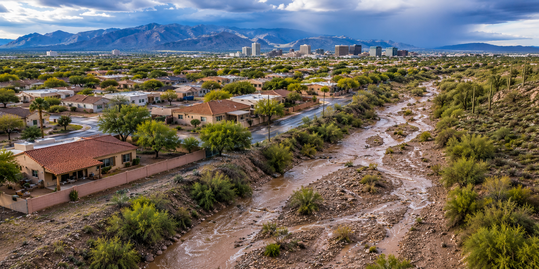
When people think about flooding, Tucson probably isn't the first place that comes to mind.
We live in the Sonoran Desert, after all.
But anyone who has experienced a strong summer monsoon knows how quickly conditions can change. A wash that is completely dry most of the year can suddenly carry fast-moving water, streets can experience temporary flooding, and intense rainfall can create runoff in places that looked perfectly dry only a few hours earlier.
For homeowners and buyers, that makes understanding flood zones especially important.
The confusing part is that terms like flood zone, floodplain, FEMA map, wash, and flood insurance requirement are often used interchangeably even though they don't necessarily mean the same thing.
This guide breaks down the basics, explains the resources available in Tucson and Pima County, and—most importantly—shows why looking at the specific property is more useful than simply asking whether a neighborhood is "in a flood zone."
Why Does Flooding Matter in the Tucson Desert?
Direct Answer: Tucson's desert climate doesn't eliminate flood risk. Intense thunderstorms can produce substantial runoff over short periods, while washes and drainage channels carry stormwater through the landscape. Flood and erosion conditions can therefore vary considerably from one property to another, making local drainage and property-specific information important even in an arid environment.
One of the easiest mistakes to make in Southern Arizona is assuming that a dry landscape means there isn't much water to worry about.
Desert flooding works differently.
Instead of the prolonged rainfall that may cause flooding in other parts of the country, Southern Arizona can experience intense thunderstorms that release a large amount of rain over a relatively small area.
Water then moves across the landscape through streets, drainage systems, low areas, and the network of washes that naturally cross the region.
That's why the City of Tucson maintains a formal floodplain and erosion-hazard management program, including flood-risk mapping and floodplain-management standards. The City's current Floodplain Administration resources also include its updated Floodplain Management Plan, flood and erosion information, construction resources, and links to FEMA mapping. City of Tucson Floodplain Administration
The important takeaway is simple:
Living in a desert doesn't mean living without flood risk.
What Does a Flood Zone Actually Mean?
Direct Answer: A flood zone is a geographic area FEMA identifies according to mapped flood hazard. Flood zones help communities, lenders, insurers, property owners, and builders understand flood risk and certain regulatory or insurance requirements. A property's FEMA designation is useful information, but it should not be interpreted as a guarantee that flooding will—or will not—occur.
FEMA publishes Flood Insurance Rate Maps, commonly called FIRMs.
According to FEMA's National Flood Insurance Program, these maps show community flood hazards, including flood-zone boundaries and, where applicable, base flood elevations. National Flood Insurance Program — Flood Zones and Maps
One term you'll see frequently is Special Flood Hazard Area, or SFHA.
Pima County explains that an SFHA is an area determined to have a 1% or greater chance of flooding in any given year, sometimes referred to as the "100-year floodplain." Pima County Regional Flood Control District — Floodplain Mapping
That phrase can be misleading.
A "100-year flood" does not mean flooding happens only once every 100 years. It describes an annual statistical probability.
Flood zones are therefore better understood as risk classifications, not calendars predicting when the next flood will happen.
Understanding Common FEMA Flood Zones
Direct Answer: FEMA uses lettered flood-zone designations to communicate different levels and types of mapped flood hazard. In inland Southern Arizona, buyers commonly encounter A-series and X designations. A zones generally identify higher-risk Special Flood Hazard Areas, while X zones can represent moderate or lower mapped risk depending on how the zone appears on the flood map.
Here's a simplified overview:
| FEMA Designation | General Meaning |
|---|---|
| Zone A | High-risk Special Flood Hazard Area |
| Zone AE | High-risk area where detailed flood analysis and base flood elevations are generally available |
| Zone AO | High-risk area associated with shallow flooding, typically sheet-flow conditions |
| Shaded Zone X | Moderate mapped flood hazard |
| Unshaded Zone X | Lower mapped flood hazard |
| Zone D | Flood hazard is possible, but risk has not been fully determined |
FEMA identifies A, AE, AH, AO, AR, and A99 as high-risk flood areas. Moderate- and lower-risk areas include certain B, C, and X designations. National Flood Insurance Program — What Is My Flood Zone?
There is one distinction I think is particularly important:
Zone X does not mean "no flood risk."
FEMA specifically notes that flooding can occur outside mapped high-risk areas. In fact, NFIP data for 2014 through 2024 shows that nearly one-third of claims came from outside current high-risk flood areas. National Flood Insurance Program — What Is My Flood Risk?
So when you're evaluating a property, "It's in Zone X" shouldn't automatically end the conversation.
It's one piece of information.
FEMA Maps and Pima County Flood Information Aren't Exactly the Same Thing
Direct Answer: FEMA flood maps and local Pima County floodplain resources serve related but different purposes. FEMA's FIRMs establish federally mapped flood-hazard areas used for the National Flood Insurance Program and certain lending requirements, while local agencies also manage drainage, erosion, development, and floodplain issues specific to Southern Arizona.
This distinction is incredibly useful for Tucson homeowners.
The FEMA Flood Map Service Center is the official federal source for effective Flood Insurance Rate Maps and related mapping information. FEMA Flood Map Service Center
Locally, the Pima County Regional Flood Control District works with floodplain management, flood-control planning, drainage, mapping, and other flood-related issues throughout the region. Pima County Regional Flood Control District
Properties within Tucson city limits may also be subject to City of Tucson floodplain and stormwater requirements. The City maintains its own Floodplain Administration resources and engineering standards. City of Tucson Floodplain Administration
Why does that matter?
Because a simple real estate website map or a quick glance at a FEMA zone doesn't necessarily answer every drainage or floodplain question you might have about a particular property.
For property-specific research, official federal and local resources are much more useful.
Why Tucson's Washes Matter
Direct Answer: Washes are natural drainage features that can carry stormwater during rainfall events even when they remain dry for long periods. Because Southern Arizona rainfall can be intense and localized, the presence of a wash, drainage path, or erosion hazard near a property deserves careful evaluation rather than assumptions based on how the area looks during dry weather.
If you're new to Tucson, washes can be deceptive.
Some look like sandy walking paths.
Others are lined with mature desert vegetation.
And many remain completely dry for most of the year.
But they're part of the natural drainage system of the Sonoran Desert.
During heavy rainfall, water can move through these channels quickly.
That doesn't mean every home near a wash has the same flood exposure. Elevation, drainage design, channel characteristics, flood-control improvements, and the location of the structure all matter.
It does mean that a dry wash should never automatically be interpreted as an inactive drainage feature.
The safest approach is to rely on official floodplain information and qualified professionals when property-specific conditions need to be evaluated.
Does Being in a Flood Zone Mean You Need Flood Insurance?
Direct Answer: Flood-insurance requirements depend on the property's mapped flood hazard, financing, lender requirements, and other circumstances. Federal rules generally require flood insurance for certain properties in Special Flood Hazard Areas when secured by federally regulated, supervised, or insured lending, while lenders may impose additional requirements. Property owners should verify coverage requirements directly with their lender and insurance professional.
This is another area where broad statements can create confusion.
According to the National Flood Insurance Program, properties in high-risk Special Flood Hazard Areas with certain federally backed or regulated mortgages are subject to mandatory flood-insurance requirements. Lenders may also require coverage in circumstances where federal rules do not. National Flood Insurance Program — Eligibility
And there's another important distinction:
Standard homeowners insurance generally does not cover flood damage.
The NFIP advises homeowners to review separate flood-insurance options and explains that coverage may be available even when a property isn't located in a high-risk zone. National Flood Insurance Program — Flood Insurance Eligibility
Because premiums and requirements are property-specific, a real estate agent isn't the right person to estimate what a particular homeowner's policy will cost or determine which coverage is appropriate.
Those questions belong with the lender and a qualified insurance professional.
What Should Buyers Review Before Purchasing a Tucson Home?
Direct Answer: Buyers evaluating a Tucson or Pima County property can review official FEMA mapping, local floodplain information, seller disclosures, visible drainage conditions, insurance requirements, and available property records. When flood or drainage concerns arise, qualified floodplain, engineering, insurance, inspection, or other appropriate professionals can provide property-specific guidance beyond the scope of a general real estate evaluation.
Flood research doesn't have to be complicated, but it should be thoughtful.
A useful due-diligence process may include:
- Check the official FEMA map.
Use the FEMA Flood Map Service Center, rather than relying solely on third-party real estate websites. - Review local floodplain information.
Pima County and the City of Tucson maintain resources that can provide additional local context. - Read property disclosures carefully.
Pay attention to information concerning previous flooding, drainage, erosion, or other conditions disclosed for the property. - Look at the physical site.
Observe grading, drainage paths, nearby washes, retaining structures, and how water appears intended to move around the home. - Ask about insurance early.
If insurance could affect your purchase, waiting until the end of the transaction to investigate coverage can create unnecessary surprises. - Bring in specialists when appropriate.
Engineers, floodplain officials, inspectors, insurance professionals, and other qualified specialists can address questions that fall outside a real estate agent's expertise.
Arizona's real estate rules specifically recognize flood and drainage conditions as important matters in development documentation, and REALTOR® ethical standards require agents to avoid exaggerating, misrepresenting, or concealing pertinent property facts while also recognizing that agents are not expected to provide expertise in unrelated technical disciplines.
That's an important boundary.
Your real estate professional can help you identify information and resources, but technical conclusions about hydrology, engineering, insurance, or legal implications should come from the appropriate professionals.
What Should Current Homeowners Know About Floodplains?
Direct Answer: Homeowners should check applicable floodplain and drainage requirements before making improvements that could affect grading, drainage, structures, or regulated floodplain areas. Requirements vary by property and jurisdiction, and work that seems minor may still involve local floodplain or engineering standards. Property-specific questions should be directed to the appropriate Tucson or Pima County authority.
This becomes especially important when homeowners are considering projects such as:
- Building an addition
- Constructing a wall
- Changing site grading
- Adding structures near a wash
- Modifying drainage
- Building certain accessory structures
- Making substantial improvements to a structure in a regulated floodplain
Within Tucson, floodplain and drainage requirements are incorporated into the City's engineering and development standards. City of Tucson Engineering Codes
Pima County also administers floodplain requirements in areas under its jurisdiction.
The best time to find out whether special requirements apply is before designing or beginning the project.
Can Flood Maps Change?
Direct Answer: Yes. Flood maps can change as agencies obtain updated topographic information, complete new engineering studies, construct flood-control improvements, or revise flood models. FEMA has formal processes for map revisions and amendments, so homeowners should use current official mapping rather than assuming a flood designation remains permanently unchanged.
This is another reason I don't recommend relying on an old listing or paperwork from a previous transaction.
Flood maps evolve.
For example, Pima County documents past FEMA Letters of Map Revision (LOMRs) that changed mapped Special Flood Hazard Areas after improved data and modeling became available. Pima County Floodplain Mapping
FEMA also provides processes such as:
- Letter of Map Amendment (LOMA)
- Letter of Map Revision (LOMR)
- Other formal map-change procedures
The City of Tucson's Floodplain Administration page currently includes information concerning preliminary FEMA map updates and revalidated map-change documents, reinforcing the importance of checking current records. City of Tucson Floodplain Administration
If flood-zone status matters to a transaction or planned improvement, verify the current designation rather than relying on historical information.
Flood-Zone Resources at a Glance
Direct Answer: Understanding flood risk usually requires more than one source. FEMA provides the federal flood maps used for National Flood Insurance Program purposes, while Tucson and Pima County agencies provide local floodplain, drainage, erosion, and development information. Lenders and insurance professionals address separate financing and coverage questions for individual properties.
| Resource | What It Helps Explain |
|---|---|
| FEMA Flood Insurance Rate Map | Federally mapped flood-hazard areas |
| FEMA Flood Map Service Center | Official map lookup and map documents |
| Pima County Regional Flood Control District | Local floodplain, drainage, mapping, and flood-control information |
| City of Tucson Floodplain Administration | City floodplain, erosion, development, and mapping resources |
| Mortgage lender | Property-specific lending and coverage requirements |
| Insurance professional | Available coverage, premiums, limits, and policy questions |
| Engineer or floodplain specialist | Technical property-specific drainage or flood questions |
No single source answers every question.
That's why flood research is most useful when federal mapping, local information, and property-specific professional guidance are considered together.
Common Flood-Zone Misconceptions
Direct Answer: Flood terminology can easily create false certainty. A lower-risk FEMA designation doesn't mean flooding is impossible, a dry wash isn't necessarily irrelevant, and the phrase "100-year flood" doesn't mean flooding occurs once every century. Understanding these distinctions helps homeowners and buyers interpret flood information more accurately.
"I'm in Zone X, so my house can't flood."
Zone X indicates a lower or moderate mapped risk depending on the designation—not zero risk. FEMA reports that flood claims also occur outside high-risk areas. National Flood Insurance Program — What Is My Flood Risk?
"A 100-year flood happens once every 100 years."
No. The term refers to a statistical 1% annual chance of flooding in the mapped area.
"The wash behind the house is always dry."
A wash may remain dry most of the year while still functioning as a drainage channel during storm events.
"If flood insurance isn't federally required, there isn't flood risk."
Insurance requirements and physical flood risk are different questions. Lower-risk areas can still experience flooding.
"The flood zone shown on a real estate website is all I need."
Third-party maps can be useful for initial research, but official FEMA and local-government resources should be used when verifying flood information.
Frequently Asked Questions About Tucson Flood Zones
Is Tucson really at risk for flooding even though it's a desert?
Yes. Intense thunderstorms, runoff, washes, drainage patterns, and localized rainfall can create flood and erosion hazards in Southern Arizona.
What is a Special Flood Hazard Area?
A Special Flood Hazard Area is a FEMA-mapped area with a 1% or greater chance of flooding in any given year. These areas generally include high-risk A-series flood zones in inland locations such as Southern Arizona.
Does Zone X mean a Tucson property cannot flood?
No. Zone X represents moderate or lower mapped flood hazard depending on the specific designation. It does not mean there is no possibility of flooding.
Where can I check a property's FEMA flood zone?
The official federal source is the FEMA Flood Map Service Center. Pima County and the City of Tucson also provide local floodplain resources that may offer additional context.
Do homes in FEMA flood zones require flood insurance?
Some properties in Special Flood Hazard Areas are subject to federal flood-insurance requirements when certain mortgage financing is involved. Lenders can also have additional requirements. Buyers should confirm requirements with their lender and insurance professional.
Can a property's flood-zone designation change?
Yes. FEMA flood maps can be revised as new studies, modeling, topographic information, or flood-control improvements become available.
Should I rely on my real estate agent to determine whether a property will flood?
A real estate professional can help identify available information and resources, but predicting flooding or providing hydrological, engineering, legal, or insurance conclusions is outside the normal scope of real estate expertise. Property-specific technical questions should be directed to qualified professionals.
Final Thoughts
Flood zones can sound intimidating, especially when you're looking at a map filled with letters, shaded areas, washes, and technical terminology.
But the basic idea is much simpler.
A flood map is a tool for understanding risk—not a prediction of exactly what will happen to a particular home.
For Tucson and Pima County residents, the most useful approach is to look at the complete picture: FEMA mapping, local floodplain information, the physical characteristics of the property, available disclosures, and guidance from the appropriate professionals when technical questions arise.
And perhaps the biggest misconception worth leaving behind is the idea that "desert" and "flooding" are opposites.
Southern Arizona's washes, monsoon storms, drainage systems, and floodplains are all part of the same desert environment.
Understanding how they work simply gives homeowners and buyers better information about the properties they're evaluating.
Educational Disclaimer
This article provides general educational information and is not intended as legal, engineering, hydrological, insurance, or floodplain-management advice. Flood conditions, map designations, development requirements, insurance requirements, and property characteristics vary. For property-specific questions, consult the appropriate government agency, lender, insurer, engineer, attorney, or other qualified professional.

Tom Krieger
| The TJK Team - Realty Executives Arizona Territory
or another way